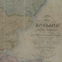
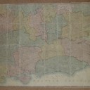
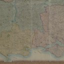

1830 Large Scale Map Grand Tour of Southern England M Phillips
Stock Number: 160219
£195
1830 Map England M. Phillips, Civil Engineer Surveyor Engraved Printed Jon Hebner London
Dimensions
72
Circa
1830
Country of manufacture
UK and Ireland
Description
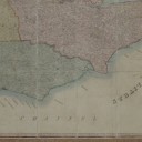
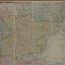
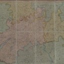
‘The Grand Southern Tour Of England, including a principal part of the East, West & Inland Counties’
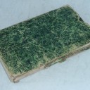
Folding map: dissected into 48 sections and mounted on linen.
M. Phillips, Civil Engineer Surveyor, Engraved by Jon. Hebner, London.
Good, bright original hand coloured map, some minor wear, but overall in very good sound condition with original but worn slip case.
72″ x 40″ or 1830mm x 1018mm
************************
‘Patronised by HRH King George the IV His Royal Highness Frederick Duke of York Commander in Chief etc. Several others of The Royal Family The Universities of Oxford & Cambridge’
********************************
A large scale map of the southern part of England, showing each town, village, church, hall, country home, woods, city, ancient sites, and all the roads crisscrossing this rich and varied landscape.
Extending from the south coast up to Cambridge and Stratford and from Ramsgate to the mouth of the Severn, the map covers the most prosperous parts of England with enough detail to have been a map that a traveller could easily have used to journey
Ask the Dealer
Dealer information
 Cog Scientific

As a fine art sculpture graduate I have applied my appreciation and understanding of form and function to my lifelong professional career in the antiques trade. Over forty years dealing in what I considered worthy, within the fields of decorative arts and sciences, I have always purchased over a wide spectrum and look forward to offering an exciting variety of stimulating pieces.